
In law the Definitive Map of Public Rights of Way is “conclusive evidence” of the existence of a public right of way specifying routes to be footpaths, bridleways, restricted byways and byways open to all traffic. The law also says that it is “conclusive evidence” to the particulars in the statement to position, width as well as any limitations or restrictions.
The role of preparing the original mapping rested on the “Surveying Authority” – for most of the county this was the pre 1974 County Council but Gloucester City was the old County Borough. In rural parishes the surveying authority was also the highway authority but in parishes which were Urban Districts or Municipal Boroughs, those councils were the highway authority.
The process envisaged the collection of information on existing rights of way from Parishes leading to the publication of a draft map, with a period of public consultation, publication of revisions to the map, with more consultation but only on the deleted or added paths, followed by the publication of a provisional map and ultimately the publication of the “Definitive Map”. The legal process then envisaged five yearly reviews which would have enabled any missing or newly created paths to be added or any diversions, extinguishments to be corrected.
The pioneering National Park and Access to the Countryside Act was passed in 1949 and I once naively assumed the original map was all done and dusted by the mid-1950’s and there had been perhaps four or five reviews before the law and processes was reformed by the Wildlife and Countryside Act 1981. Had they been it would be pretty obvious that the “Definitive Map” would have been what it says on the tin; but it took many years to do the original map and no reviews were ever done. In practice we have a ramshackle of chaotic archaic maps dating from the 1960s and 1970’s based on the rural and urban districts which were abolished in March 1974.
For the Stroud District there are primarily five definitive maps, Stroud Urban, Nailsworth Urban Stroud Rural, and Dursley Rural and Gloucester Rural, but there are also two original maps which cross over the boundary with South Gloucestershire.x
| Map Area | “relevant date” | Draft Published | Revised Draft Published | Modify Draft Map | Provisional Published | Definitive Map | Coverage and Parish Boundary change |
| Stroud Urban | 1 March 1953 | 2 November 1972 | 1 March 1973 | 7 June 1973 | Stroud (whole) Cainscros (part) Randwick (part) Rodborough (Part) Brimscombe and Thrupp (Part) | ||
| Stroud Rural | 1 March 1953 | 3 May 1965 | 19 March 1971 | 21 February 1974 | 16 Parishes around Stroud including Painswick, Bisley, Chalford Stonehouse | ||
| Nailsworth Urban | 1 March 1953 | 2 November 1972 | 1 March 1973 | 7 June 1973 | Nailsworth | ||
| Dursley Rural | 1 August 1953 | 2 Oct 1953 | 28 October 1960 | 3 May 1965 | 23 October 1973 | 11 parishes including Dursley, Cam Wotton, Kingswood, Slimbridge | |
| Gloucester Rural | 1 June 1953 | 28 October 1960 | 3 May 1965 | Covers 35 parishes in 5 Districts – 14 in Stroud District. 1 new parish created | |||
| Thornbury Rural | 31 December 1953 | 9 October 1973 | Mostly South Glos but covers Alkington, Berkeley, Ham and Stone, Hamfallow and Hinton. | ||||
| Sodbury Rural | 1 January 1954 | 28 May 1965 | Alderley remained in Gloucestershire in 1974 but Hillsley and Tresham returned in 1991 |
Dare I ask who has custody of the original sealed copies? This became a fundamental legal issue in Portsmouth where this was discovered missing. This is perhaps most relevant in terms of Sodbury and Thornbury, has Gloucestershire actually created a definitive map for these areas or is there some legal fiction that the two authorities “share” a map? What does the law provide in these circumstances? Was it covered in the 1974 transfer orders and also more recently in the 1991 transfer orders when primarily Hillsey and Tresham were returned to Gloucestershire “proper” or perhaps more correctly North Gloucestershire?
What we do know is that the public reference copies at Shire Hall are now in poor condition and even if the sealed copy is legally compliant it is time for a thorough updating of what is now 70 year old record.
What constitutes the Definitive Map?
As set out in the original 1949 legislation the definitive map consisted of the map showing the routes and statement describing them. Ramblers Association “Blue Book Extra” publishes extant legislation and guidance which sets out the expectations of what was to be included, part of which included Ministerial endorsement of an Open Spaces Society/Ramblers Association document which advised on the extent of information to be collated by Parishes and others, including the numbering of paths and collection of information on limitations and restrictions on rights of way.[1]
The subsequent Wildlife and Countryside Act 1981 defined things slightly differently in making the publicly available information to be:-
- The Definitive Map
- The Statement
- “copies of all orders modifying the map and statement”
That final requirement refers to copies of a Modification Order made under Section 53(6) relating to BOTH legal event modification orders under Section 53(3)(a) and full orders arising from discovery of evidence under Section 53(3)(c) (as well as orders under Section 53(3)(b)).
The case for a Consolidated Map
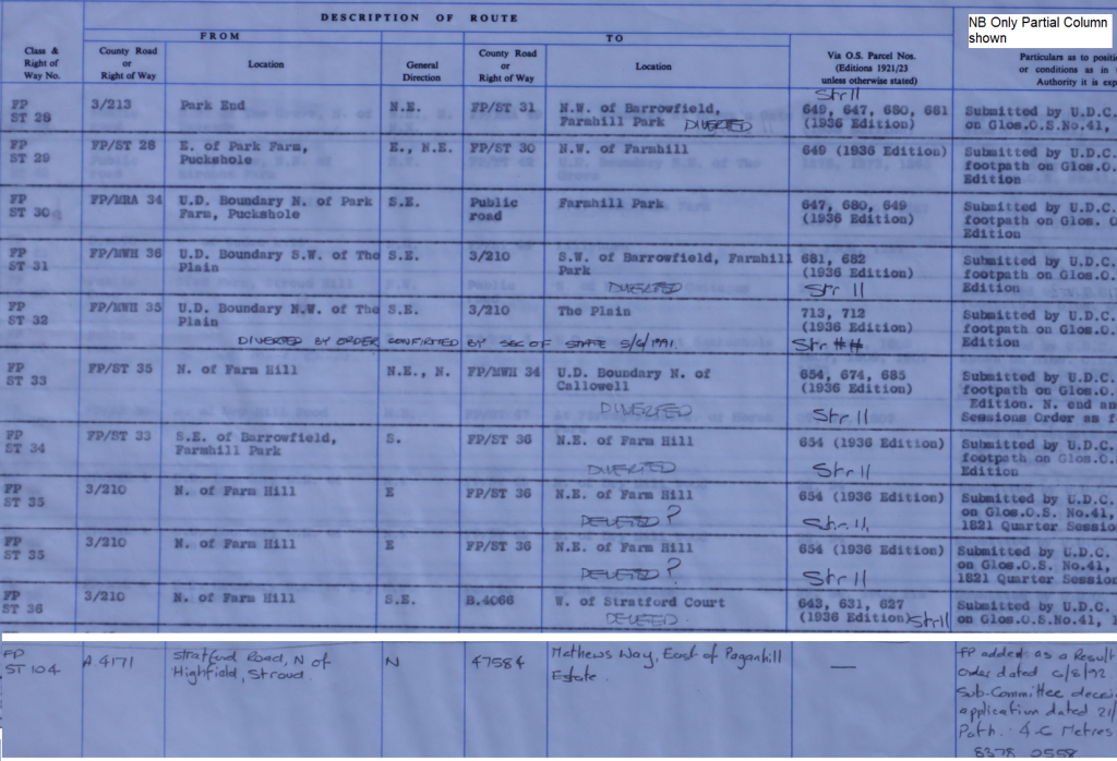
The record of public rights of way consists of two documents which need to be read in conjunction with each other the definitive map and the statement. The map shows Footpath ST25, ST26, ST27, ST28, ST29, ST30 ST32, ST34, ST35, ST36, ST82 and ST103. The extract from the statement shows ST28 to ST36, which shows 9 of the paths on the map in addition there is a manuscript entry added for ST103 on the map and ST104 on the statement.

In fairness to Gloucestershire they have invested in an on-line “unofficial map” but there also anomalies and errors between what is shown on the on-line map and the legal Definitive Map
What is shown on the Definitive Map as Stroud Footpath ST36 runs from Farmhill through the edge of Stratford Park is shown as running through the gardens of two adjoining properties, but it has also been renumbered as ZST34 – or rather what was shown on the map as ST34 has been extended to cover part of ZST36, following development at the northern end, where part of ZST36 was extinguished.
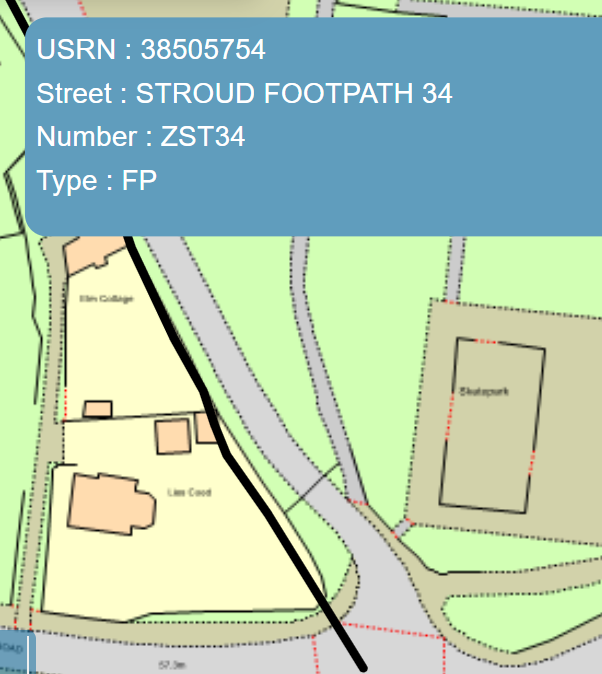
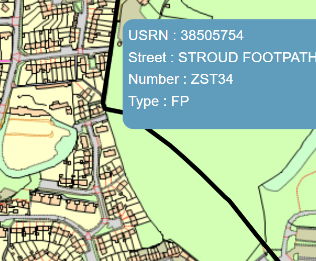
Top and bottom ends of ZST34 shown on the on-line map
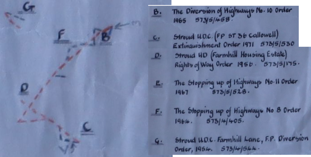
Within the definitive map books are additional overlays on high quality tracing paper on which are shown various orders to divert, extinguish or create new rights of way. I have always assumed that this was confirmation that the Definitive Map had been updated, but I am beginning to doubt this whether all the t’s have been crossed and all the i’s have been dotted
The examples shown below date from before Definitive Map was formally sealed in June 1973 but because the map was recording the rights of way as at 1 March 1953 they are not legally included. Any changes from 1 March 1953 were due to recorded on the 1st review which would have taken place by 1978, but never took place. Which takes us to the “new” processes under the Wildlife and Countryside Act 1981. Have the required Modification Orders been made under Section 53(2)(a) been made for legal events before 28 February 1983? What we know for certain is that at least two paths created by order E are not shown on the on-line mapping nor are they listed in the schedule (not illustrated on this map). Likewise for G the diversion specifies a new termination point and a width of 42 inches for the diverted section, again there is no revised statement.
[1] Open Spaces Society and Ramblers Association, SURVEYS AND MAPS of PUBLIC RIGHTS OF WAY, produced in BBR05 Historical definitive map acts, regulations and guidance https://www.ramblers.org.uk/advice/paths-in-england-and-wales/rights-of-way-law/the-blue-book/the-blue-book-extra.aspx